
31 October 2014
No updates yet...
As it turns out, I haven't run Tomahawk yet and won't get to it until Saturday afternoon. Reports will be out late this turn.
Day 2 - 10:45 a.m.
Things will start happening at Tomahawk tonight. Locust Grove might not be until tomorrow (Saturday). I will wait until one or the other reaches a good stopping point and then make sure that both battle maps end at the same time. Official reports are likely to be out on Sunday, but some interim updates may appear before then.
30 October 2014
WIA5 in 2015
The Army of the Arkansas and Department of the Eastern Frontier have just started to tangle with each other in THE OZARKS CAMPAIGN (WIA4). There is still a lot of fighting and campaigning to do in this simulation, but plans are already starting for WIA5. It will use the same campaign theatre, but a very different simulation concept. More information on WIA5 will start coming out in November.
29 October 2014
WIA_St_Leger Now Available
The St. Leger modded map is now complete and available for download on the WIA MOD Links page and the Madminute Games forum. The map has roads connecting it to Lead Hill, Rapp's Barren and (yet to be completed) Bennett's Bayou on the campaign map for THE OZARKS CAMPAIGN command simulation. It is on the northern route across the White River, where the campaign map allows movement from Lead Hill to St. Leger without having to control the river crossing in-game. (Talbot's Ferry, North Fork and Sylamore all have crossings which could be defended at the ford/pontoon bridge, making it more challenging to cross.)
There are four town maps that still need to be completed. They are all in the northeast corner the campaign theatre and represent parts of Fulton and northern Izard Counties. The remaining maps to be completed are:
- Bennett's Bayou- Cross Plains- Franklin- Pilot Hill
Bennett's River and Union (appearing on period maps) were removed from the WIA campaign map for simplification purposes. The location of Cross Plains and Franklin were also slightly altered on the WIA map. Cross Plains will be the next map under construction. It no longer exists on contemporary maps and it is now known as Pineville, in Izard County. The WIA map for Cross Plains will be based on an area around Pineville.
I was prepared to quickly put together proxy maps for the remaining towns in the campaign theatre and was going to use Anderson's Crossroads for Cross Plains. The Anderson's Crossroads is a map available on the Madminute Games forum that has always been one of my favorites (long before I knew how to do anything related to modding maps). Because the action in THE OZARKS CAMPAIGN so far has focused on the southwest section of the campaign theatre, it is allowing me to slowly finish off the remaining towns as custom maps based on actual topography for the area.
Speaking of THE OZARKS CAMPAIGN, orders are starting to come in and fighting is likely to continue (and be potentially heavy) over the weekend.
Finishing up...
With the houses and objects in, I have thrown a little more color on the base, painting in the road and darkening the base around fields and woods. I have finally taken the wheat off the roads and replaced it with a few rocks. With a few corrections and final touches and then adding the ambient sounds, St. Leger should be ready in the next day or so.


28 October 2014
Setting Houses
I have most of the terrain the way I want it at St. Leger, so now I am starting to set the houses. I have them marked on my tga file and then convert the coordinates for landscape studio (invert X and Z coordinates and then multiply by 64). Then I select an object (e.g. Pfeffer House), place it on the map, set the coordinates and then adjust the elevations.
I have a hard time understanding my position in studio, because it is almost like working in a snow storm. I usually save it, load it into the file for the game and then open up a test to see how the house is positioned. (I still have the roads marked with wheat for now.) I then decided if the object has to be rotated and then go back into studio to fix it and add any outbuildings.


I have a hard time understanding my position in studio, because it is almost like working in a snow storm. I usually save it, load it into the file for the game and then open up a test to see how the house is positioned. (I still have the roads marked with wheat for now.) I then decided if the object has to be rotated and then go back into studio to fix it and add any outbuildings.
St Leger Minimap
As I get ready to place houses, barns and other buildings, I mark the main buildings on the tga map. From there, I can get their positions for placement with landscape pro. I can also start puiting together my minimap for the game, that eventually becomes WIA_St_Leger_MM.dds, one of the four map files that will be used to run the modded map when it is done. I made some parchment-like textures that I have been using in all the WIA minimaps.
I guess I could wait until last for the minimap, but it helps me navigate while I am checking how the houses look and whether their elevations and facing look correct.

I guess I could wait until last for the minimap, but it helps me navigate while I am checking how the houses look and whether their elevations and facing look correct.
The Flood Plain
The thick, brushy, flood plain between where St. Leger will be (no houses yet) and the North Fork River is starting to take shape. It will have a heavy movement rate and fatigue penalty. Roads are the key....

27 October 2014
Bridge over the North Fork
With the roads generally OK, I put in some crops, marked where my houses will be and marked a crossing of the North Fork River. The first object (houses, bridges, etc.) that I put in was a pontoon bridge. I am trying to decide whether or not to make the crossing to Bennett's Bayou (as per the historical map) or make it outward to other parts of Missouri (as per the modified campaign map).
I am also looking at the big open space between the hills and town to the north and river to the south. Originally, I thought I might make it a swamp, but the elevation is a little high for that. I might make it some kind of big, nasty, brushy, flood plain.

I am also looking at the big open space between the hills and town to the north and river to the south. Originally, I thought I might make it a swamp, but the elevation is a little high for that. I might make it some kind of big, nasty, brushy, flood plain.
St. Leger Roads
In the same way I use bright trees to check the positions of creeks and rivers on the map, I tend to use wheat to check how the road network looks. It is easy to see while looking at the placement of the roads and testing whether they "path" correctly - allowing troops to move across an unbroken road network. I plan to make St. Leger a very small settlement (only a couple of houses) at the junction shown here.


Back to St. Leger - Rivers and Creeks
With the first engagements having started at Tomahawk and Locust Grove, I am back to map making until orders come in again on Friday. Back at St. Leger, I am working on the rivers, after a few challenges on my grayscale files. The grayscale file is named WIA_St_Leger.tga and it shows were terrain features will be located. WIA_St_Leger.csv is a comma separated value file (like an excel file) that gives grayscale values on the tga file features by linking them to sprites (image files of terrain features)defensive bonuses, fatigue penalties, visibility limits, etc.
To put in rivers and creeks, they are depressed into the terrain using landscape studio and then the water level is adjusted to the height desired. But.... for them to register in the game, there must be a corresponding river on the flat, WIA_St_Leger.tga file to give it the fatigue penalty and put in rocks or reeds. I have a hard time lining the elevations and grayscale map up. To do it, I temporarily put some kind of tree or something into the river so I can see the boundaries. In this case, I used WIA_Brush_1, because it is bright yellow and easy to see. I can see that I need to adjust the banks of one of the tributary creeks. (The way it is now, if units are on the banks, it will read as if they are in the creek.)

Once I am sure the grayscale file is aligned with the terrain elevations, I will remove the bright yellow trees by taking them out of the csv file (possibly replacing them with some rocks or reeds for the streams).
26 October 2014

Herling vs. Randall - Not a New Rivarly
Brig. Gen. Paul Herling and Brig. Gen. Charles Randall engaged around the H. R. Lee house as I/DEF and I/AOA were starting to clash at Wilson's Junction. Those who followed the WIA2 Campaign know that Herling (then a Colonel) and Randall clashed in earlier campaigns and their opposing cavalry brigades are well known to each other.
Herling and Randall May 4th
During the WIA3 Campaign, the two brigades met during the Battle of Crane near Younger Junction, engaging through the late morning and holding their lines against each other at the end of the battle.
Herling and Randall's positions at Crane (July 4th)
Herling and Randall May 4th
During the WIA3 Campaign, the two brigades met during the Battle of Crane near Younger Junction, engaging through the late morning and holding their lines against each other at the end of the battle.
Herling and Randall's positions at Crane (July 4th)
25 October 2014


Reports Out
All reports for Day 2 at 10:45 a.m. have been sent out. If I missed you or you need any clarification let me know. The next turn is a tactical turn starting at 10:45 a.m. Tomahawk and Locust Grove are battle maps. Orders are due Friday October 31st.
Division Commanders - Report up to your Corps Commanders and await any instructions before submitting your orders. There's no rush. No further action will take place until Friday night.
Division Commanders - Report up to your Corps Commanders and await any instructions before submitting your orders. There's no rush. No further action will take place until Friday night.
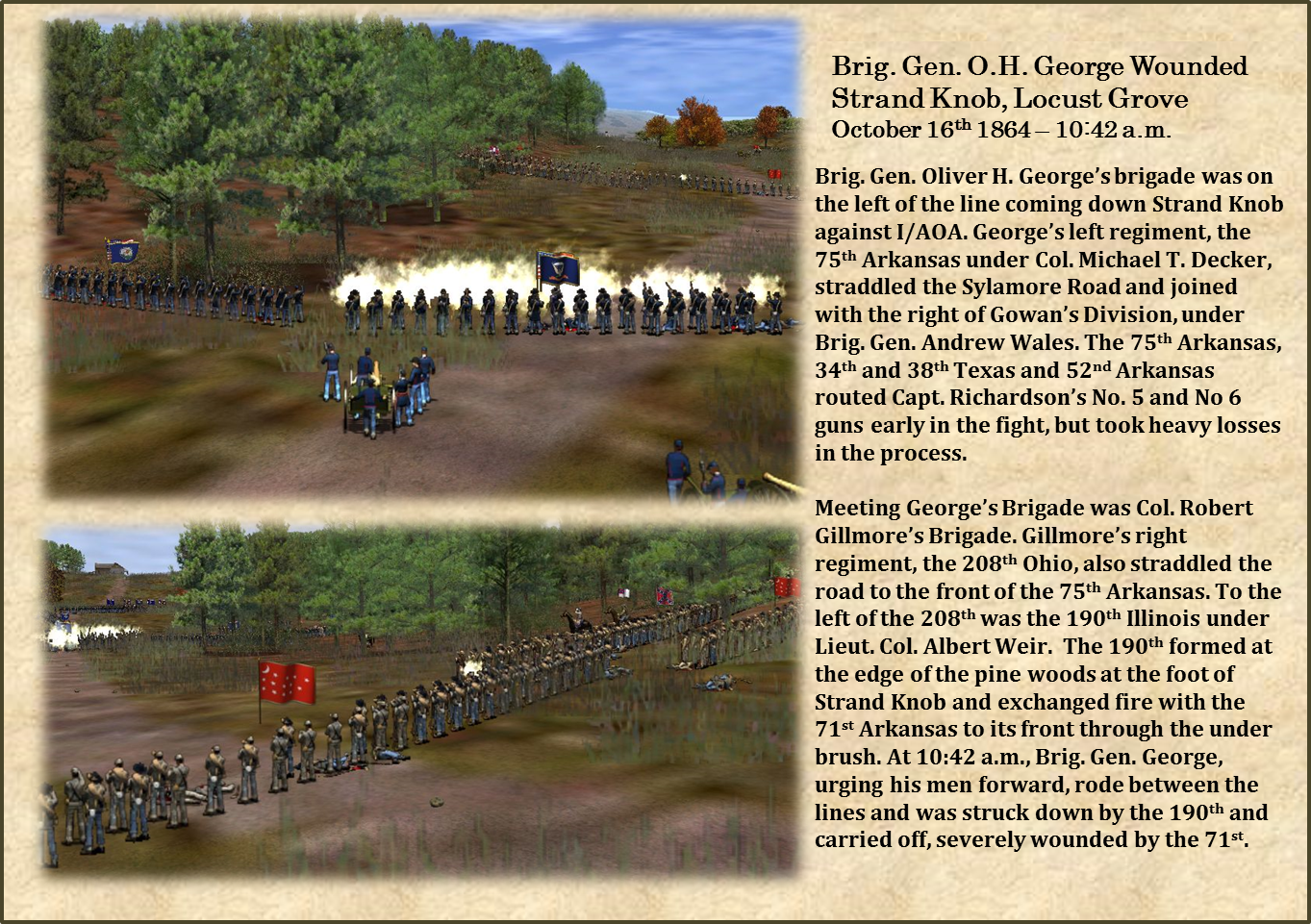
Confederate Brigadier Generals Down
As an assault has been launched against the AOA I Corps, rumors are already filtering back through the line that DEF has lost one or more brigadier generals on Strand Knob at the opening of the attack.
Reports Starting
Usually I send reports out in one bunch, but given the number of players, I will be sending them out in batches according to HQ location. I am about to send out the first back and will continue throughout the weekend until they are finished in this order:
- AOA at Tomahawk
- DEF at Tomahawk
- DEF at Locust Grove
- AOA at Locust Grove
- AOA at Tomahawk
- DEF at Tomahawk
- DEF at Locust Grove
- AOA at Locust Grove
24 October 2014
Day 2 Tactical Turn 1 Over
The 1st Tactical Turn of Day Two of the Campaign is over at 10:45 a.m. I waited for some engagement and then stopped both maps at the same time, so the time will be the same across the campaign theatre. Reports for D2/1045 will be out later this weekend.
Locust Grove is now a battle map. Total casualties across both battle maps from 10:00 - 10:45 a.m. were about 2,150. Because the losses are relatively light, most reports will be limited to screenshots and a brief status report.
Locust Grove is now a battle map. Total casualties across both battle maps from 10:00 - 10:45 a.m. were about 2,150. Because the losses are relatively light, most reports will be limited to screenshots and a brief status report.
Confederate Attack Against Wilson Junction
The Confederate I Corps moves against the Wilson Farms at the junction of the Freight and Sylamore Roads. Confederate infantry have come over Strand Knob and across Buzzard Roost to attack the Federal I Corps, which is deployed at the junction...


Cavalry at H. R. Lee
Herling's Brigade is engaged with Randall's Brigade at the H. R. Lee House, southwest of Strand Knob. Herling has the advantage of high ground and the house, but Randall is supported by batteries shelling Herling's men from near Locust Grove to the north. One of the batteries firing on Herling is Gage's Battery of 20 pound Parrott Rifles.


Shelling at Locust Grove
The fighting at Locust Grove has kicked off with Confederate batteries at the edge of Locust Grove town exchanging fire with Federal batteries near the Wilson houses.

First Rounds Fired....
Most units are still far from being in position, but the first rounds of THE OZARKS CAMPAIGN have been fired across Baker's Spring Branch on Clinton Road....


Day 2 - 10:00 a.m. - Lines push forward
All orders are in for Day 2, starting at 10:00 a.m. It may take a while (possibly all weekend) before reports are in, but fighting is expected at Tomahawk and Locust Grove.....
23 October 2014
Hill of St. Leger
Once the height.tga has been done and the lines made a bit blurry, it is entered into landscape studio (software) and it creates the topography of the map. Here the hills of St. Leger emerge.
St. Leger's town will probably be about where a supply wagon is visible on the right hand side in the screenshot below of the foot of the hill further to the left. The flat area in the foreground will be swamp and river and a stream will be in the valley between the two hills. Putting in the water system will be my next step and one that I find a bit challenging.


The area used for the map is from this section of a topographic map. The river level is much higher now, so much of what is depicted as North Fork Lake in the map will be lowland and swamp. The WIA roads will be entered similar to their position in the topographic maps

St. Leger's town will probably be about where a supply wagon is visible on the right hand side in the screenshot below of the foot of the hill further to the left. The flat area in the foreground will be swamp and river and a stream will be in the valley between the two hills. Putting in the water system will be my next step and one that I find a bit challenging.
You can see that they are a little "rough around the edges" on the one side. Some areas need to be smoothed out a little using the software.
The area used for the map is from this section of a topographic map. The river level is much higher now, so much of what is depicted as North Fork Lake in the map will be lowland and swamp. The WIA roads will be entered similar to their position in the topographic maps
22 October 2014
Construction in Progress
The current map under construction is for St. Leger, which is actually in southern Missouri. The map is still in the early stages at the height.tga file. This file is not visible, but will be inside the file that will eventually be called WIA_St_Leger.lsl. The height.tga is rotated 90 degrees clockwise, so what appears on the eastern side will actually be on the northern end of the finished map. Light areas are high and dark areas are low, so you can see some fairly steep hills leading to a very low (dark) area, which will eventually have some swamps and the North Fork River.
The height.tga for St. Leger still has to be blended and blurred a little so that the hills are smooth and don't look like Aztec pyramids, but before the roads, water, trees, grass and houses, this is how the topography starts....
Movement between Lead Hill, Rapp's Barren and Bennett's Bayou through St. Leger, will be through the hilly portion of the map. It will be heavily (very heavily) wooded, so it will be challenging terrain. Any movement in the current campaign theatre will be on the west side of the river, so it will not be necessary to cross the North Fork here in THE OZARKS CAMPAIGN. The crossing point will be presumed to be further south and not defendable in the simulation.
21 October 2014
Orders coming in....
Orders are due this coming Friday, but already some orders are starting to flow in from Division Commanders.

20 October 2014
New Map Coming This Week....
This week there should be another map release for THE OZARKS CAMPAIGN operating theatre. The next map to be released will be Wild Haws, which was in Izard County at the time of the war. It has since been renamed as La Crosse. Wild Haws was settled by the Watkins family from Tennessee, who were slave owners and built a large two-story brick building, which was unusual in the area during the ante-bellum era. Wild Haws is flatter than a lot of the other towns in the campaign theatre, with longer lines of site around many parts of the map.
Wild Haws is on the eastern end the campaign theatre, between Mount Olive and Franklin. The map should be released later this week.


Wild Haws is on the eastern end the campaign theatre, between Mount Olive and Franklin. The map should be released later this week.
19 October 2014
Who, What, When, Where, Why and How.... to Attack
With the opposing sides having met at two town across THE OZARKS CAMPAIGN, both armies are strategizing on the particulars of attack and defense. There will be at least some firing somewhere in the vicinity of Baker's Spring Branch, south of Tomahawk Town. How extensive it will be and how it will develop from there is anyone's guess. Those who remember WIA3 will recall The Battle of Midway, which started with some modest fighting and then one side slipped off, and The Battle of Crane, where the two sides met by chance and it became a massive, two-day engagement.
Orders are due by Friday, but they are already starting to trickle in for some corps.
Orders are due by Friday, but they are already starting to trickle in for some corps.
18 October 2014
Adams Advancing
Looking north up Clinton Road from Baker Spring Branch. Kraft's Brigade is deployed on a rise between the creek and town.


Maj. Gen Adams and Brig. Gen. Kraft, with Maj. Gen. Rooney and his division advancing south down Clinton Road from Tomahawk Town.

These are from the march as at around 10:00 a.m., prior to issuing specific deployment orders (due next Friday.
Lead Hill Now Available
The Lead Hill map is now available for download on the blog and forum. I think you will enjoy it.
Next Orders - Friday October 24th and Tactical Turn Notes
Orders for Day 2 - 10:00 a.m. are due by Friday October 24th. This is a tactical turn and implications for orders have been sent out to each corps with the corps reports.
Tomahawk is a "Battle Map." All infantry divisions at Tomahawk (or arriving at Tomahawk in the next turn) must submit their orders separately by their Division Commanders.
To maintain the integrity of stances, elements of at least one division from each opposing corps will engage at least lightly before completing any other orders. By default, this would most likely be units along the road, the lead of the engaging corps and the rear of the defending corps or division closest to the road.
The reason or this is so that if you set on engage, you know that you will engage in the first tactical turn, at least lightly. If you then want to back off and establish a defensive line, that is OK, but muskets will fire from at least one division. Likewise, if you set for defend, you will also be engaged if the enemy sets for engage. You can still withdraw, but will have to fight a rear guard action.
So.... during campaign mode:
1. Engage Stance: You will engage, at least lightly with your lead division, if you come up against an enemy corps set on defend or engage. Any other deployment or movement orders will take place during or immediately after this engagement.
2. Defend Stance: You will engage, at least lightly with one division, if you come up against an enemy corps set on engage. Any other deployment or movement orders will take place during or immediately after this engagement.
3. Do Not Engage Stance: You will keep giving way before the enemy and no tactical turn will be declared.
I/DEF and I/AOA both took a defensive stance at Locust Grove, so no engagement has taken place. They will be allowed to give deployment orders for defensive positions within a limited area (marked by blue and red on the D2/1000 map). Additional infantry may not be brought onto Locust Grove unless one side orders an attack against the enemy and there is engagement.
Nuances: If I/DEF orders an attack on I/AOA in the next turn, DEF could order infantry into the fight at Locust Grove from Wiley's Cove or Lebanon. If I/AOA orders an attack on I/DEF positions in the next turn, it could order infantry into the fight from Big Flat, Sylamore, or Richwoods. The arriving infantry would arrive roughly halfway into the tactical turn and begin marching to the assigned deployment positions.
Because a battle map has been declared, any infantry sent to Tomahawk from Lebanon or Yellville will arrive at the edge of the map at the beginning of the tactical turn and start marching towards their positions.


Subscribe to:
Posts (Atom)